Interest in Mexican California was growing in the East long before the gold rush. The imagination of government officials and eastern adventurers was sparked by the stories filtering back East from fur trappers and visitors who extolled the mild climate, the fertile soil, the abundant fruits and vegetables, and the grace and vigor of the horses even into old age.
In 1842 Captain John Charles Fremont, as part of the United States Topographical Engineers (forerunner of the Bureau of Geological Survey), was commissioned to explore and chart the western portion of this continent. To be included in his reports were routes, trails, landmarks, natural environment, and the suitability of the land for settlement.
By the first part of the year in 1844 Fremont, with the famous Kit Carson as a guide, had reached the eastern base of the Sierra Nevada Mountains. Traveling south, he searched for a break in the crest where they could cross the steep snow covered peaks. Although warned by the Indians about the extreme danger of crossing in the winter, Captain Fremont was determined. They forged ahead, starting up the eastern slopes of the Summit in early February. It took nearly three weeks to accomplish the feat. This summit later became known as Carson Summit. Kit Carson carved his name and the date, 1844, on a tree there. This tree has since been cut down and may be viewed at Sutter’s Fort in Sacramento. With the spirits of some of the men sagging, food meager, and snow and ice taking its toll, the company continued north along the summits of the ridges soon reaching the American River. They then traveled down to a “dry open place in the ravine” (most likely Strawberry). After “about 10 miles the valley opened a little to an oak and pine bottom” where they camped. There is some speculation that they then traveled over the hill to Georgetown and from there to Sutter’s Fort. The way across the rugged Sierra Nevada Mountains had been surveyed and mapped.
In April of 1848, before news of the discovery of gold had spread to the east, the Mormon Battalion that had been in California during the Mexican War was called back to Utah by Brigham Young. Some of the men had been working in Sutter’s flour mill at Mormon Island (now inundated by Folsom Lake) and others in the building of the lumber mill at Coloma when gold was discovered there. They did a little prospecting but heeded the call of Brigham Young to come back to Salt Lake City, in the Utah Territory.
An advance group of Mormons traveled to a “pleasant little valley” and there waited for the rest of the troops to gather and the snow to melt. This became known as Pleasant Valley. They then traveled from west to east over the summit Captain Fremont and Kit Carson had explored earlier, cutting a trail as they went. It has been assumed that nearly all of the early trails and routes followed those made by animals and Indians, avoiding the highest mountain peaks and deep, swift river crossings as much as possible.
One of the Mormons, James Calvin Sly, found a large parklike meadow in which to graze the stock. This became known as Sly Park. They built a corral in Sly’s park and waited while three men scouted the trail ahead. When the scouts didn’t return, the rest went on east looking for them and found them in a shallow grave presumably killed by Indians. Thus the place was named “Tragedy Springs”. They reburied the men and covered the graves with rocks.
As the Mormon group traveled on east they met westbound wagons headed for California. They described the landmarks and sent the wagons back over the trail they had just cleared, thus establishing this as the “Mother Road” of El Dorado County. The names, Tragedy Springs, Leek Springs (named after the abundance of leeks growing there), Sly Park, and Pleasant Valley were all used as land marks. The following year, 1849, James Calvin Sly led a wagon train from Salt Lake City back over this same trail, stopping again at Sly Park to prospect 3 or 4 days for gold. Not having any luck, they traveled on to Sacramento.
Emigration to California increased rapidly and even though the old emigrant road over Carson Pass was rough, crossing deep canyons and rocky peaks often made impassable by snow, the pioneers would not be daunted. Many of them continued to use The Carson Emigrant Road, but some searched for an easier route over the Sierra Nevada Mountains.
A man by the name of John Calhoun Johnson is given official credit for opening a better, shorter trail or “cut off” in 1849 down the American River watershed. It was supposed to save about thirty miles of travel. Johnson’s Cut Off came up the ridge top from Placerville, on the south side of the American River’s South Fork, went down and forded the river below Pacific House, then known as Pacific. It then continued up Peavine Ridge north of the river, staying up high on the hill and turning east over what is now known as Granite Springs Road, then coming back down to the river on the other side of present day Kyburz.
In the early 1850’s emigrants were coming into California at a frantic pace. With the need for a more organized form of government, California was granted statehood on September 9, 1850.
The roads, at best, were horrendous. Neither the state nor the counties were appropriating money for road maintenance. The upkeep of the public roads was designated to road commissioners of each district who were given the authority to require each able bodied boy and man to work his share or be fined. Still the roads were nearly impassable. Another solution was to allow an individual or company to charge travelers fees for using certain parts of the road, making that individual responsible for the construction and upkeep of the road. This proved to be a viable solution as the more well kept the road was, the more it was traveled. Some of these toll roads were later taken over by the county. Johnson’s Cut Off was declared a public road on August 5, 1853.
With the ever growing population, the need for a stage line to connect California to the eastern states was discussed. The state legislature in 1854 was willing to appropriate money for a stage road from Sacramento to Carson Valley. Johnson’s Cut Off seemed to be the favored route. In 1855 the recommendation for this route stated that the summit was 2000 feet lower than that of the Carson route, and this would seem to be a suitable route for both a stage and the Central Pacific Railroad. Getting to Sportsman’s Hall was easy. It was from there over the summit that was the difficult part. Obtaining statewide agreement for any one route over the Sierra’s seemed difficult, if not impossible, but Yolo, Sacramento, and El Dorado Counties agreed to meet and adopted a resolution to obtain $50,000. Bids were taken and contracts let with a Mr. Brockliss working on the Slippery Ford Hill, (Twin Bridges area).
The road improvements were going slowly and meeting with many obstacles and deterrents. Most authorities thought a stage could not make it over the mountains with the road in its unfinished condition, but J. B. Crandall couldn’t wait for completion of the road. He decided to hasten the construction by proving that a stage could travel between Placerville and the Utah Territory. The Mountain Democrat of July 11th, 1857 said, “The road is however, open between Placerville and Genoa,… Col. J. B. Crandall has made it a stage road. He is the first man in America who has ever established a stage line to cross the Sierras.” He took a four-horse Concord stage starting out with 7 passengers and 500 pounds of freight. The Saga of Lake Tahoe describes the trip in detail. Leaving Placerville at 2:45 a.m., the stage arrived at Sportsman’s Hall at 6:00 a.m. and there the group had breakfast. This was the farthest east a stage coach had ever gone. By 5:00 p.m. they had arrived at Clear Creek Station at the base of Peavine Ridge and there changed horses and spent the night. Up and on their way at 5:00 a.m., they reached the summit before noon and scrambled down the steep eastern slope. They changed horses again before going over Luther Summit and dropped into Hope Valley (Nevada) in time for supper. The total trip of sixty four and one half miles took less than twenty seven and one half hours. They were met by a jubilant group of representatives from Sacramento and El Dorado Counties, and also the Utah Territory (Nevada). A new mode of travel over the Sierras had begun. Contracts for road improvement were quickly let, and a semi-weekly stage line with overland mail from Placerville to Genoa, Carson Valley, and Salt Lake City began on May 18, 1858. Passenger fare from Placerville to Salt Lake City amounted to $125. On July 19, 1858, the first Overland Coach from the east successfully arrived in Placerville and ran regularly until the completion of the transcontinental railroad in 1869.
John A. Thompson, a native of Norway, came to the United States with his family in 1837 at the age of 10. The allure of gold brought him to Hangtown in 1851 where he worked as a miner. He then moved to a ranch on Putah Creek and while there read of the trouble getting the mail across the summit of the Sierra Nevada Mountains during the snowy winter months. He decided to make a pair of snowshoes fashioned after those he remembered from his boyhood in Norway. They were 10 foot long “skis” four inches in width. They weighed twenty-five pounds as they were made of oak. Thompson made his first trip transporting mail from Placerville over the summit to Carson Valley in January of 1856. He traveled the distance of 90 miles in three days over snow thirty to fifty feet deep. The trip back took two days. Snow-shoe Thompson became a fixed institution of the mountains for over the next 20 years. Most of his trips brought him up the ridge past Sportsman’s Hall, and then up the ridges above the American River. No matter how violent the storm, Thompson made it through with mail bags weighing between 60 and 80 pounds. He never carried a blanket or wore an overcoat, but would build a fire in a tree stump or leaning tree if he slept at night. He chose a leaning tree so that if it burned through and fell during the night, he would be on the safe side. He often traveled both day and night. He made his bed from cedar boughs next to the fire or under an overhanging rock. He was guided by the landmarks by day and the stars by night and never got lost. He had an intuitive sense of direction. He was a large man standing six feet and weighing 180 pounds. He had blond hair, fair skin and blue eyes like his Norwegian ancestors. Although he was not paid for the government mail contracts, he believed that if he continued to do the work, he would eventually be compensated. He never was. Snow-shoe Thompson was a dedicated servant to mankind, but this venture was unsuccessful financially. He died May 15, 1876 at his ranch in Diamond Valley, thirty five miles south of Carson City, Nevada. He was forty-nine years old. His widow had a pair of snow-shoes carved in the headstone of his grave in Genoa, Nevada. He was truly a legend in his own time.
The Central Overland Pony Express Company began their short-lived but well celebrated delivery of the mail on April 3, 1860. The riders were mainly slight, young boys, preferably orphans. What mother would let her son take such chances? Every new employee of the company owned by Russell, Majors and Waddell had to swear that, “I will under no circumstances, use profane language: that I will drink no intoxicating liquors: that I will not quarrel or fight with any other employee of the firm, and that in every respect I will conduct myself honestly, and be faithful to my duties… So help me God.”
At first a letter going by Pony Express from Sacramento to Saint Joseph, Missouri, took 10 days at a cost of $5.00 for one half ounce. Later the trip of 1,966 miles was made in 8 or 9 days and the cost was reduced to $1.00 for one half ounce. The rider rode at top speed from one station to the next. The station keeper would have a fresh horse saddled and ready to travel. It took the rider less than two minutes to change horses and grab the mochilla full of mail. On an average day one rider would ride 75 to 100 miles. However, He might have to continue on if the next rider was not available. The last run of the Pony Express was on October 24, 1861. The completion of the transcontinental telegraph made the Pony Express Company obsolete. The Pony Express route as well as the telegraph lines roughly followed the John Pearson Road and what is the present day Pony Express Trail.
Now every summer in Pollock Pines, there is a celebration with a re-enactment of the Pony Express. Riders again carry the mail from Sacramento to Saint Joseph Missouri on this one day of the year. In the winter of 1983 there were heavy rains causing the south hillside above the river just west of Kyburz to cave in and the highway to be closed for many weeks. The Pony Express riders once again carried the mail, circumventing the slide area to get the mail to its destination. A special Pony Express cancellation stamp was made and letters came in from all over the country to receive this keepsake cancellation mark.
The discovery of the Comstock Lode in Virginia City, Nevada, in June of 1859 brought even more constant streams of humanity, vehicles, and goods over the mountains, headed for Sacramento. It is said, you could stand in one spot and 300 wagons would pass by daily. Jane Schlappi in Historic Sites states that “5000 teams plied the road between Placerville and Virginia City during the early 1860’s. If for some reason you stopped along the road, you would have to wait until nightfall for the traffic to slow enough to get back on.” It’s mind boggling to try to imagine all of this activity taking place in this quiet little community. The clatter of the wooden wheels, the shouts of the drivers with their whips cracking, the braying of the donkeys, and the bells of the livestock must have been deafening. The mail stage often ran at night to avoid the heavy daytime traffic of the freighters. Hauling freight became big business, with freight taken to the Nevada mines and gold and silver brought back to the mint in San Francisco. Freight rates were 6 to 10 cents a pound as a rule, but sometimes were as high as 50 cents. The load for a 12 horse team was from 14 to 18 tons and the average charge from Placerville to Virginia City was $3500.
Individuals and private companies vied for the right to operate and maintain toll roads throughout the area. Great fortunes were expended on the construction and upkeep of the toll roads, but were quickly recouped and expanded when the tolls were collected. Some way stations took in as much as $1000 in tolls in a day. A good saloon might take in as much as $3000 in a night.
The free county road up Johnson’s Cut Off, greatly affected the fortunes of the toll road operators. The freight wagons would use the better maintained toll road when traveling east with a heavy load, but would use the free county road coming back to avoid paying the toll. Mr. Bartlett had built a bridge across the South Fork of the American River (below the present Pacific Ranger Station Work Center). The bridge washed out in 1855, and Anthony Brockliss built a bridge farther east below Pacific. This later bridge became a part of the county road. One night the Brockliss bridge suspiciously exploded, forcing the traffic to use the toll road both ways.
Inns or Road Houses were established nearly every mile along every road. Along with the 5000 teamsters, scores of inn keepers, and toll road operators earned their living from the roads in El Dorado County. Unfortunately, a few bandits also earned their living along the roads.
The infamous Bullion Bend Robbery took place on June 30, 1864, about two and one half miles above Sportsman’s Hall at the bend in the road. Two coaches of the Pioneer Stage lines, one driven by Ned Blair and one driven by Charley Watson, were stopped by several armed men and robbed of several sacks of gold bullion from the Comstock Lode, reportedly for the purpose of outfitting the California recruits for the Confederate Army. One bandit was apprehended at the Thirteen Mile House. The others were followed south. There was a shoot-out in Pleasant Valley. Deputy Sheriff Joe Staples was killed, and Constable George Ranney along with one of the robbers was wounded. Nine men were subsequently arrested in Santa Clara County and brought back to Placerville for trial. On September 29, 1865, Thomas Poole was executed for murdering the sheriff. The gold was never recovered.
Another less publicized incident cited in Sioli’s book, History of El Dorado County, took place in the summer of 1867. Three men were determined to make money by robbing houses along the Placerville-Carson Valley Road. They robbed a teamster just above Sportsman’s Hall, then continued on robbing houses and a water cart driver. Under-Sheriff Hume, with a posse of men, went in pursuit. Near Osgood’s Toll House, the armed men took a shot and caught the sheriff in the arm. Hume ordered his men to shoot and one bandit was killed. One fell off the bridge and was presumed drowned, but was later tracked and caught just above Brockliss Bridge. Both surviving men were sentenced to State Prison.
Two main routes, the old Carson Emigrant Road and the Placerville-Carson Valley Road, ran from east to west across the county, but in actuality a whole network of roads existed. Travelers could come over the summit on the old Carson Road, then head north at Sly Park and come up to the Placerville-Carson Valley road passing by the Sportsman’s Hall and other inns along the way; or they could come over the summit on Johnson’s Cut Off, and then head south at Fresh Pond House and go down Stark’s Road or Pleasant Valley Road into Diamond Springs or El Dorado; or they could use any number of combinations of the road network. The main trunk of the Placerville-Carson Valley Road, along the ridgetop from Camino east to Sportsman’s Hall and beyond, had many springs, necessitating a 5 inch thick plank road from the 9 mile House to the 14 Mile House. The Pioneer Stage Line had leased the road in 1863 and agreed to put down the planking. In 1860 the stage fare one way from Placerville to Genoa was $30 and to Saint Joseph, Missouri, was $375.
Mr. Ogilby had two toll roads running east to west. His main road left the Placerville-Carson Valley Road east of Sportsman’s Hall at the 14 Mile House (Holcom House), turned south and then east, going to the south of Union Hill. It then came in at Fresh Pond. From there it divided into two roads and continued up the south bank of the river, past Plum Creek, and came back down to the American River above Whitehall. One of the Ogilby Roads ran lower on the hill than the other. The upper road had lots of hills and gulleys, so Mr. Ogilby built the lower, more level road to keep in competition with the toll free county road. Union Ranch, Pennsylvania House, and Esmeralda House, at the head of Esmeralda Falls (now called Bridal Veil Falls), were on the Ogilby road. The road bed, though overgrown with shrubs and some trees as tall as 80 feet, can still be seen on the hillside across the river from Whitehall. The ditch above the road washed out some of the road in 1875. And the heavy rains and subsequent collapse of the hillside in 1983 destroyed another section.
Brockliss Grade crossed the river north of Pacific over Brockliss Bridge and went up the north side of the river but stayed lower, closer to the river, than the Johnson’s Cut Off road. Both of these road beds can still be seen.
John Pearson bought a road for $1650, called the South Fork Toll Road. It began 1 mile west of Sportsman’s and ran east in front of Sportsman’s, and the old 13 Mile House, then along the south side of South Fork Hill, past Fresh Pond House, Pacific House, and Moore’s Station (Riverton) on the South Fork of the American River. The road then crossed the river and went along the north side of the river to about one quarter of a mile west of Dick’s Station (Kyburz). This is approximately the present route of Highway 50.
Starks Road in Pleasant Valley, owned by W. A. Stark and Co., ran between Diamond Springs and the west end of the Ogilby Road. It was eight and a half miles long and was declared a public highway August 7, 1888. Very few improvements have been made to the road through the years except for widening.
The Road from 14 Mile House to Sly Park meadow was declared a county road in the summer of 1859, with the wagon road from Starks Grade to Ogilby Road being declared a county road in early 1910. In 1916 Sly Park Road was realigned from the 14 Mile House to Sly Park, at first following Ogilby Road, then down to Stark’s Road then south until it joined the Pleasant Valley Road on the west side of the Sly Park meadow.
W. Bartram had a road from the spring on the south side of the Placerville-Carson Valley Road near the 13 Mile House that went to the Bartram’s Pacific Mill (Pacific House), 17 miles east of Placerville. He sold this road to David Ormrock and Peter Watt on February 7, 1865 for $2000.
The comforts of the railroad as compared to the rough ride of the Stage were being extolled. The people in Placerville realized the importance of a route crossing the Sierras in this area and fought to obtain it. The railroad companies were exploring two options: The Johnson’ Cut Off, and the Placer County route surveyed by chief-engineer Theodore Judah. Sioli states that ex-governor Stanford explained that negotiations were taking place with the owners of the toll roads going over the Sierra Nevada Mountains in El Dorado County, but negotiations broke off when the toll road operators wanted to receive a controlling interest in the railroad. Sioli suggested that the Sacramento interests feared also that with the completion of the El Dorado route, the railroad might bypass Sacramento to the south, going through Stockton and Galt. Thus the acceptance of the Dutch Flat route was to be expected. The completion of the Central Pacific Railroad over Donner Summit in 1869 ended the great bonanza for the toll road owners, teamsters, and inn keepers of El Dorado County, and the roads deteriorated from lack of care.

1923 Road Crew

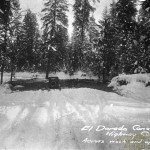
State Highway1 in 1923, just above Whitehall

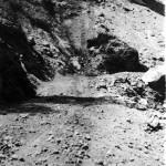
State Highway 1 near Fresh Pond
The Main Placerville-Carson Valley Highway, later known as the Lincoln Highway, became State Highway 1 in 1896 and still later became Highway 50. In the early 1920’s the road was still little more than a trail going over the summit. The part of the road from 8 Mile House to 14 Mile House was straightened in about 1923 and again in the 1940’s. Signs of the curves of the old road following the natural terrain can still be seen as the curving entrances to many of the trailer parks along Pony Express Trail.
The Pollock Pines area began as a stop on the way to “somewhere”, and the local economy still thrives on tourism. In the early 1960’s the road became so congested on Sunday evenings with travelers coming home from Lake Tahoe, that it seemed surely one would have to wait until nightfall, like days of old, before pulling out onto the roadway. A Freeway was completed in 1965 to the south of the business area, and the old road was renamed Pony Express Trail.
All images for this chapter, and additional photos not in the original book are shown below.
Photo Gallery for Early Routes and Roads
-
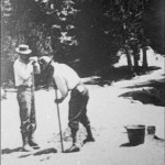
- 1923 Road Crew
-
- State Highway 1 near Fresh Pond
-
- State Highway1 in 1923, just above Whitehall