Water, being necessary to the gold mining process, became the center of many contentions in the early 1850’s. The South Fork Canal Company was formed on July 10, 1852 to bring water to the mines in Placerville from the South Fork of the American River.

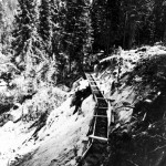
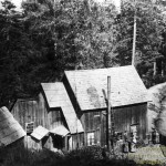
Early Wooden Flume
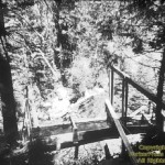
The soil wasn’t suitable for a canal so a wooden flume was built four feet wide and three and one half feet deep. The joints were covered with canvas. The flume went from the South Fork of the American River, at the foot of Randolf Canyon, to Long Canyon, then to Reservoir Hill. The flume had a grade of 4 feet per mile. John Kirk was involved in building the reservoir. It took from 1853 until 1854 to complete the 25 miles of flume. Due to oversight and carelessness, the cost far exceeded the $500,000 allocation.
An example of the carelessness comes from Sioli’s book. When Mr. Springer went to find tack hammers to nail the strips of canvas over the cracks in the flume, there were none available except in a certain harness shop. They were not for sale. He finally convinced the owner to rent a dozen hammers to him for fifty cents a day each. At the end of the job the hammers were inadvertently thrown into the tool-house. When the owner finally inquired about them and they were returned, the bill amounted to over $900.

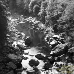
The South Fork of the American River below Pacific House in the fall of the year
The demand for water far exceeded the supply. The streams and creeks and even the South Fork of the American River slowed to a mere trickle in the summer and fall. The South Fork Canal needed to be supplemented. With foresight, in 1856, John Kirk claimed rights to the water of the South Fork of the American River. He also had storage claims on Silver, Willow, Twin, Audrain, Echo, Medley, and Glacier Lakes. He surveyed for the canal, the head of which was to be located at Cedar Rock, 40 miles east of Placerville. The line would run from there to Sportsman’s Hall, then on to Blakeley Reservoir, 6 miles east of Placerville. Kirk and his partner, engineer, F. A. Bishop, lacked money to start the canal. Papers of Incorporation were filed for the El Dorado Water and Deep Gravel Mining Company on September 4, 1873. Money was finally acquired and all of the existing main canals and ditches with their many branches were purchased. Thus the company had acquired rights to all of the watershed of the South Fork of the American River with its contributing streams, including the summit lakes which feed them. At first they tapped only the reservoirs at Silver and Echo Lakes.

Early wooden flume from above
Work began on the Sportsman’s end of the canal. It took 3 years to build about 4 miles of canal and complete the dams at Cedar Rock and Silver Lake. It was decided the canal should be completed for the Country’s Independence Day Centennial Celebration so the work was pushed forth. The canal was hand dug mostly by Chinese labor. Ditch walkers, even now, sometimes find articles left behind by the Chinese laborers. The main trunk of the canal began at Cedar Rock and came west to the junction with Iowa Canyon. It then went past Sportsman’s Hall to join the South Fork Canal then continued on to Smith’s Flat, a total of 40 miles at a cost of $500,000. Less than 5 miles consisted of wooden flume. It was completed and ready to carry water on July 1, 1876, with days to spare. The canals were built on steep hillsides with earth embankments. The curves were constructed with ample radius to allow the virgin timber on the surrounding hillsides to be harvested and floated down the canal. For the first few years until the ground settled and firmed, there were lots of wash outs and repairs.
To increase the flow of water in the canal, a tunnel was put through the mountain to Echo Lake. Digging was started at the south end in 1874, and then tunneling was done from both ends. They met in the center of a 1058 foot tunnel on November 5, 1875. Water found its way through to the South Fork of the American River on August 3, 1876. Downstream water sold for twelve and a half to twenty cents per inch depending on its proposed usage.

Dunkum House at Ditch Camp #2
Men were hired to walk the ditch looking for and repairing leaks. Mr. Dunkum was responsible for the section between Camp 2 and Camp 5. Camp 2 was located where the present PG&E camp is now located just east of Bullion Bend. (The numbers of the ditch camps have been reversed since early times). The Dunkums lived in a house there below the ditch from 1891 until they moved to Placerville in 1901. Janice Chappell’s grandmother, Buelah Dunkum, was born at Ditch Camp # 2 in 1898. The children walked the 3 miles to the Cedar Grove School. Their closest neighbors were the Butlers, west of Randolph Canyon. They borrowed the Butler’s wagon twice a year to go into Placerville for supplies. The wood shed was built over the ditch, so that wood cut east of the house could be floated down, pulled out, and stacked inside the shed. The Camp 2 house was later moved to a site above the ditch.
The ditches were constructed with an eye single to the purpose of mining operations. El Dorado Water and Deep Gravel Mining Company’s canal was no exception. The most important mine of the company was the Excelsior mine, a hydraulic mine south of Placerville. Excelsior mine included White Rock, Reservoir Hill, and Spanish Hill Mines. Hydraulic mines have overlying rock strata that will yield to the force of water under high pressure. The gravel washed down then travels through sluices with bars to catch the gold. The gold sinks because it is heavier than the soil and water. Overlying strata in drift mines is too hard to wash down, so the gold has to be extracted by other means.
In 1884 a law was passed prohibiting the washing of dirt and soil into the river. Hydraulic mining came to a halt. The demand for water for mining purposes diminished, but water for agriculture was now in demand. Agriculture was now an established enterprise in El Dorado County.
Through several transfers and a foreclosure, El Dorado Water and Deep Gravel Mining Company became the property of the Western States Gas and Electric Company in 1916. In 1917 the dams at Twin Lakes were built and the dams on other lakes rebuilt.
Through court action, the ditch system and properties below the 14 mile tunnel (Pollock Pines) were purchased by The El Dorado Water Company for $25,000, including the right to purchase other water at a wholesale rate. A dam was constructed on Weber Creek and the financially troubled company was reorganized as the El Dorado Water Corporation.
The El Dorado Irrigation District was formed on October 5, 1925, under state irrigation district laws and took over the troubled El Dorado Water Corporation. The need for water was still acute and a storage dam at Hazel Valley was proposed. Land was purchased for $80,000, but the plan was abandoned with the onset of the depression. Government aid was applied for and denied. The Bureau of Reclamation studies established Sly Park as the feasible water storage reservoir, but felt that financial obligations could not be met by the District.

Forebay Lake in 1923 as it was being built
Congressman Clair Engle finally pushed through congress Bill H R 165, authorizing the Army Engineers to construct Folsom Dam and the United States Bureau of Reclamation to build Sly Park Powerhouse and dam. This integrated the project with the Central Valley Project which was created to help down stream counties. It was called the Folsom Formula, meaning when a dam is built in the lower lands, the counties upstream should share in the profits. Sly Park Dam was begun and finished in 1955 forming Jenkinson Lake, named after the E. I. D. secretary-manager, Walter Jenkinson, who was so persistent and successful in acquiring additional water for this county. Sly Park furnishes water for the Sly Park Hills and Sierra Springs areas as well as some of the lower foothill communities.

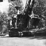
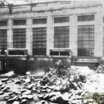
Paddy steam engine used to build Forebay Lake
![[Medley Dam in 1923]](images/Placeholder.gif)
Medley Dam in 1923
(PG & E photo)
Western States Gas and Electric Company owned the interest in the canal from Pollock Pines to Silver Fork including the dams for the Rock Creek Powerhouse. The dams were rebuilt on Medley, Silver, Echo, and Twin Lakes. The ditches were cemented and Forebay Lake and El Dorado Powerhouse were built in 1922.
")
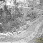
The ditch above Forebay Lake during resurfacing (1923)
Water from Forebay Reservoir is pumped up to a reservoir on Union Hill and distributed by gravity to upper Pollock Pines, Fresh Pond, Gold Ridge, and Cedar Grove. Some of the water is released to continue on west through the ditch. Some of the water from the ditch is now diverted into Sly Park because of the 1987-88 drought conditions. Of course some of the water goes down to the American River through the penstock to generate electricity in the El Dorado Powerhouse.
")
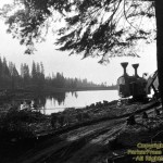
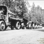
Early equipment truck (1923)

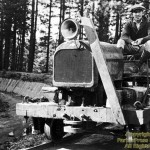
Rail car, called a Mule because it replaced a mule

El Dorado Powerhouse (picture Courtesy of Lucien Fisher
El Dorado power-house required a maintenance crew, so ten company houses, a club house, and a dormitory with a school up-stairs were built on the north side of the American River. A foot-bridge was built to get to the little community. Robert Fisher of the Academy of Ballet in Placer-ville was raised there. His father, Lucien Fisher, was a maintenance man at the El Dorado Power-house.
While the powerhouse was being built, Western States Gas and Electric Company had their head-quarters at the top of Forebay Road on the south side of Highway 50, (about where Safeway is now located). The State took it over and used it as a maintenance station when the highway was being realigned. When the El Dorado Power-house became automated in 1947, the families moved up from the American River, and the buildings there were closed. American River Powerhouse further down river, was built in 1926 and has 3 penstocks. PG&E bought out Western States in 1927.
The home of the Lucien Fisher family at the El Dorado Powerhouse facilities on the South Fork of the American River. (Lucien Fisher photo)
When Mr. Pollock put in his subdivision, he also put in a water system, taking the water from Weber Creek. The community took over the water system and formed the Pollock Pines Water Company. The community had difficulties keeping the system working and it was taken over by E. I. D.
With the Sacramento Valley’s need for electricity increasing, Sacramento Municipal Utilities District (SMUD) began looking for mountain lakes to store water to generate power. Construction was begun on the dams at Slab Creek, Whiterock, Union Valley, Ice House, and Loon Lake. By the 1960’s these dams and powerhouses were well under way. The lakes thus formed provide pleasant recreation areas now being managed by the U. S. Forest Service. The electricity is sold to the Sacramento Valley users.

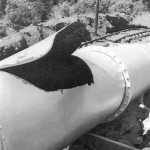
A rip in the penstock that runs from forebay lake to the El Dorado Powerhouse on the South Fork of the American River. About 1940
All images for this chapter, and additional photos not in the original book are shown below.
Photo Gallery for Wather and Hydroelectrics
-
- Early Wooden Flume
-
- The South Fork of the American River below Pacific House in the fall of the year
-
- Early wooden flume from above
-
- Dunkum House at Ditch Camp #2
-
- Forebay Lake in 1923 as it was being built
-
- Paddy steam engine used to build Forebay Lake
-
- The ditch above Forebay Lake during resurfacing (1923)
-
- Early equipment truck (1923)
-
- Rail car, called a Mule because it replaced a mule
-
- El Dorado Powerhouse (picture Courtesy of Lucien Fisher
-
- A rip in the penstock that runs from forebay lake to the El Dorado Powerhouse on the South Fork of the American River. About 1940